
The Eastern Sierra around Mammoth Lakes California is one of the greatest hiking regions of the country, but due to the lack of any national parks in the area, the region is relatively unknown! About 30 minutes to the north of Mammoth, the June Lake area has some amazing hiking, and one of those awesome hikes is the Rush Creek Trail to Agnew Lake!
This short but relatively steep trail begins in the high desert and climbs into the rugged Sierra Nevada. The trail has nearly constant awesome views, exposed ledges with big time drop offs, and takes you to a mountain lake. If you’re looking for a great moderate hike in the Mammoth area, this might be the one!
Miles/Elevation:
5 miles
1,369 feet vertical gain
About Inyo National Forest:
Roadtripping to Mammoth? Check out all of our road trip planning tips!
At nearly 2 million acres, Inyo National Forest is a massive area of soaring peaks, desert, ancient forest, and incredibly rugged alpine terrain. Inyo contains the Big Pine Lakes, Mt Whitney, the lower 48’s highest peak, along with some of the world’s oldest living things, the ancient bristlecone pines.
Covering large swathes of the Eastern Sierra Nevada and White Mountains, as well as much of the Owens Valley, Inyo National Forest actually is one of the least forested national forests in the country. First protected by president Theodore Roosevelt in 1907, the forest was initially created to facilitate the creation of the Los Angeles Aqueduct.
Nowadays, Inyo National Forest is known as a world class outdoor destination. With renowned wilderness areas such as the Ansel Adams Wilderness, the Golden Trout Wilderness, and the John Muir Wilderness, many of the best backpacking routes in the country pass through Inyo.
In addition to backpacking, there are many other amazing locations in Inyo National Forest that can be easily accessed in a day, either by hiking or by car. These include Mammoth Lakes, Convict Lake, the Ancient Bristlecone Pine Forest, June Lake, and Mt Whitney.
Much of Inyo National Forest does not require fees for day use, though some limited access locations may require fees. There is no fee to park at the trailhead to hike to Agnew Lake.
About Mammoth:

Always be sure to follow the 7 Leave No Trace Principles when in the outdoors!
Located on the eastern edge of the Sierra Nevada, Mammoth is a small mountain community known for great skiing, alpine lakes, and world class hiking. The town itself, Mammoth Lakes, named for the numerous nearby lakes, has about 7,000 people, and is one of the largest communities for hours in any direction.
At around 8,000 feet of elevation, Mammoth lies just above the desert treeline. Head out of town and within a mile you’ll be in the scrubland of the high desert. Head towards the high peaks of the Sierra and you’ll very quickly enter the alpine pine forest!
Mammoth Mountain is home to the area’s top ski resort. At just over 11,000 feet, this volcanic complex gets great snow in winter, and in the summer is converted into a mountain biking mecca!
Above the town, the lakes basin offers tons of camping. Situated around Lake Mary, Lake George, Horseshoe Lake, Twin Lakes, and others, campgrounds like Coldwater and Lake Mary provide hundreds of wooded sites. Just don’t expect much for phone coverage up here!
Getting To Mammoth:
The first challenge in getting to this trailhead is to get to the Eastern Sierra. The closest town is Mammoth Lakes, and that will be most people’s base camp when hiking to Agnew Lake.
Located in the high desert of eastern California, Mammoth is a surprisingly remote place considering it’s in California. The closest sizable city is Reno, about three hours to the north. Los Angeles and Las Vegas are both a bit over 4 hours away, and the Bay Area is about 6 hours away.
The main highway to access Mammoth and the broader Eastern Sierra area is highway 395. 395 runs from just north of the Los Angeles area all the way north to the Canadian border. Reno to Mammoth is a straight shot down 395, and Los Angeles to Mammoth is a straight shot north on 395.
There are a couple of small airports in the area, namely Bishop and Mammoth Lakes. However, commercial flights are either sporadic or non-existent. Driving from a larger metro is the easiest way to access the Eastern Sierra for most.
Getting To The Trailhead:

Mammoth is bear country so make sure you’re bear safe!
Take 395 to the June Lake Loop, highway 158, just a few miles north of Mammoth. Follow 158 to basically the far end of the loop near Silver Lake. Just to the north of Silver Lake itself, turn into the trailhead just across from Silver Lake Campground. There is a large circular parking area at the trailhead.
Tips:
- If you are out early enough, the sun will be obscured and you’ll have shade.
- There is little shade. Wear sunscreen and bring lots of water.
The Rush Creek Trail To Agnew Lake:
To Agnew Lake:
From the parking area, begin hiking on the Rush Creek Trail heading south. The trail doesn’t seem like much to begin with. You’ll pass a RV park, cross a stream or two, and then head through a stand of trees behind the Silver Lake Resort. Once you pass the resort and emerge near Silver Lake itself, the hiking drastically improves.
Once you pass the resort and emerge near the highway, the trail takes a steep turn up! You’ll be able to feel it! From here, the climbing essentially does not stop until you reach Agnew Lake!
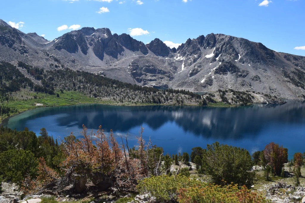
The views immediately begin opening up. Silver Lake will quickly be visible in full. Reversed Peak across the valley will continue to be a looming presence throughout the day. And in front of you, Carson Peak dominates the skyline.

Always follow basic trail etiquette when you’re hiking!
This is an awesome trail where the journey rivals the destination! The views throughout are awesome because there is little foliage to block the panoramas. You start this trail in the high desert and you’ll never truly leave it. You’ll have panoramic views the whole hike! The vistas of Silver Lake and eventually towards June Lake keep getting better and your looks east out over the desert open up too.

Driving up 395? Make sure you have the Top Down Lifestyle playlist!
While the views on their own are awesome, the hiking itself is excellent too. The trail spends almost its entire length climbing up and out of the valley containing Silver Lake. For most of that time, you’ll be right on or close to the edge.

The Mammoth Crest Loop is one of the best difficult hikes in Mammoth!
First you’ll have hundred foot drops, then a few hundred feet, and then towards the top you can look nearly straight down for over 1,000 feet! Exposure definitely makes each step more exciting!
You’ll eventually come across a railway that seemingly goes straight up the side of a mountain. I wasn’t quite sure what I was looking at when we hiked here, but there is actually a substantial amount of hydropower infrastructure up here. Agnew Lake is actually a reservoir, something I was completely unaware of, and the rail line is for servicing all that stuff!

Emerald Lake is a nice easy hike in Mammoth!
Cross the tracks (you’ll cross them again before you reach the lake), and continue climbing. Once you reach the tracks you are on the upper half of the climb. Towards the top, the trail enters some pretty sheer cliff bands, and the drops become even more pronounced than they have been!

Convict Lake is a stunning place to hike just outside Mammoth!
Continue up the switchbacks, and before long the trail will actually begin to level off! Once the trail levels off, this means you are leaving the valley that contains Silver Lake below and entering the valley holding Agnew Lake above! Continue straight past a bit of infrastructure, and you will encounter a… dam?

Hike to Ediza Lake for an up close view of the Minarets and Ritter Range!
You may have figured this out by now, but I was pretty surprised to discover Agnew Lake is actually a reservoir, but you learn something new every day! You have two choices to actually reach the lake. You’ll hit an intersection where you can either continue straight or turn left just below the dam. We turned left because we were continuing to further destinations, but the quickest route is to continue straight!

Check out Heart Lake for an easy hike in Mammoth!
Whichever route you take, you will soon arrive at Agnew Lake! The lake itself is actually a reservoir which did take away from the pristine-ness of the area, and unfortunately the water was noticeably low. This was not the picturesque alpine lake I was hoping for, but the scale of the surrounding mountains at least made up for it a bit!

Hiking Out:
Whenever you are ready to return back down the trail, head back down the way you came. There is no way to make this hike a loop other than a very very long multiple day route, so head straight back down!
The return trip should go quickly. The trail was a little bit rougher and rockier on the descent than I had remembered from the climb, and thus took a bit longer than I was hoping it would. Nonetheless, it’s a straightforward hike back, and before long you’ll be back at the trailhead!
Topdown Lifestyle Rating: 9/10
So I will admit Agnew Lake itself was a bit disappointing. I had really high expectations when I did this hike, and the lake itself isn’t really all that wonderful. It’s a reservoir surrounded by good not great mountains.
However, the hike up to Agnew Lake is really really good. While there may not be literal 1,000 foot drops off sheer cliffs, there is some decently exposed hiking up there, and the views are really good the entire time.
For me, this one is about the journey and not the destination. At 5 miles, there are not many trails that give you views this good with trail this good!
Pros:
- Awesome views
- Exposed trail
- Not very busy
Cons:
- Never truly remote
- Lake is actually a reservoir
Alternative Hikes:
When To Hike the Agnew Lake Trail:

The Eastern Sierra in general have an excellent climate for hiking, and that holds true for the June Lake area. Most days from spring until late fall you will have tons of sunshine, and storms are pretty sporadic, possible, but not daily. Temperatures can get really warm here, and with the lack of shade be sure to bring water if it’s hot!
The true limiting factor with this hike is snow. Snow can linger into the summer, and early winter storms could snow this area in early in the year. As a general rule, I’d expect this area to be snow free from May until sometime in late October or November, though shady areas in the valleys could hold snow much later.
In terms of the ideal time to visit, I would probably lean towards late spring or early summer, just after the trails are clear of snow, or fall. In spring, the trail should be clear of snow by late May or early June, but the mountains will still have lots of snow up high! In fall, you would be able to see some awesome colors as winter arrives!
One crucial thing to consider is that early season fires are much less common than fires in late summer or fall, so you are more likely to have clear, sunny days that are not choked with smoke in the spring and early summer!
Links For Further Reading:
Rush Creek Trail to Agnew Lake | Map, Guide – California | AllTrails
Rush Creek Trail: Horsetail Falls and Agnew Lake – The Lost Longboarder


