
Glacier, Yosemite, Zion, Rocky Mountain: when you say those names, images of our nation’s great national parks come to mind. And for the hiker, thoughts of some of the greatest hikes in the country.
For most, our national parks are the very best places to go hiking. And to be fair, almost all of our national parks do in fact have awesome hiking. However, what about those beautiful natural places that aren’t in a national park? Places with top tier scenery and amazing trails, but a fraction of the traffic?
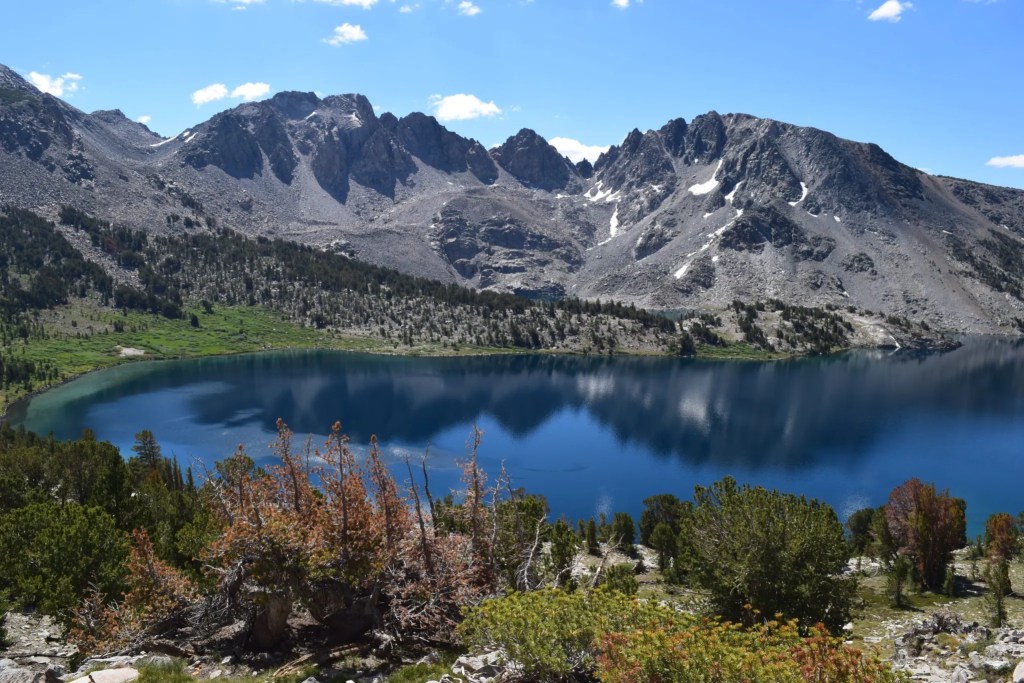
One of those incredible places that does not have national park designation is the Eastern Sierra of California. The Sierra Nevada Mountain Range does have its fair share of national parks (Yosemite, Kings Canyon, and Sequoia), but perhaps the most spectacular, and by far the most underrated region of the range is its eastern slope.
The Eastern Sierra rise nearly 10,000 feet in just a few miles in spots providing some of the most dramatic scenery anywhere in America. From the range’s base at about 4,000 feet in the Owens River Valley, 14,000 peaks like Mt Whitney and Mt Williamson are prominently visible above, nearly 2 miles up!

Check out our list of the best summit hikes in nearby Lake Tahoe!
This is one of my absolute favorite places in the country, and possibly my favorite place to hike! Certainly this is the most underrated hiking destination I have ever been!
If you’re interested in exploring this incredible area, we’ve put together a list of some of the best hiking trails the region has to offer. Hikes on this list range from towns near the southern reach of the range near Lone Pine all the way up to the Mammoth area near the center point of the range. This Lone Pine to Mammoth corridor is traversed by highway 395, and is one of the most spectacular regions of the lower 48!
I’m sure there are incredible trails that we missed, and we do not claim this is an exhaustive list of awesome trails in the region. However, we’ve hiked this area quite a bit, and I think I’ve gotten a pretty good list put together! None of these trails are easy, and to be honest there aren’t many easy hikes in the region! Be prepared for tough, long, hot hikes!
Honorable Mentions:
Valentine Lake via Sherwin Lakes
16.) Brainerd Lake
Following the South Fork of Big Pine Creek, the trail to Brainerd Lake ascends into an incredible alpine valley set beneath 13 and 14,000 foot peaks. Expect lots of sunshine and switchbacks! This hike is tough, gaining nearly 3,000 feet in only 4 or so miles, and it starts in high desert terrain.
Brainerd Lake would be an excellent end destination itself, but there are tons of possible additions to a hike here. Continue further to Finger Lake or Lake Elinore. Climb one of the massive peaks. Check out Norman Clyde Glacier. There are tons of epic ways to extend your day!
15.) Kearsarge Pass to Kearsarge Lakes
Despite the trailhead beginning at over 9,000 feet, you’ll still have about 2,500 feet of climbing to do in order to reach one of the Eastern Sierra’s most well known mountain passes. On the way up, you’ll pass a chain of 5 lakes, and at the 11,700 foot pass, you’ll have epic views back towards the lakes and desert, and far into Kings Canyon National Park.
Many will continue on over the pass and down to the Kearsarge Lakes, though this will add about 900 feet of climbing on the way back. For the more ambitious, there are tons of peaks that can be summited from this trail as well! Mt Bago is personally one of my next objectives!
14.) Minaret Lake

Check out our list of the best hikes in Grand Teton National Park too!
Beginning at Devils Postpile National Monument outside the town of Mammoth Lakes, this hike will take you deep into the Ansel Adams Wilderness to one of the most stunning lakes in the Sierra.
Nestled at the base of the stunningly jagged Minarets, Minaret Lake is a true 10/10 destination. The hike there is long, about 8 miles each way, and the scenery on the trail isn’t great until the end, but this long hike is worth it just for the final destination. You could also try this as a backpacking loop and connect to Iceberg, Cecile, and Ediza Lakes!
13.) Cottonwood Lakes

The Beartooth Mountains of Montana are another amazing non-national park place to hike!
The furthest south of all the hikes on this list, the trail to the Cottonwood Lakes begins in the Golden Trout Wilderness at the far southern end of the Sierra high country. You’ll begin at over 10,000 feet, and then follow a flat and easy going trail until climbing into the Cottonwood Lakes Basin. Once in the basin, you’ll have a set of 5 lakes to explore, and even more that are not a part of the main chain!
Lakes 4 and 5 are truly spectacular, and 1-3 are good though maybe not amazing. This can be done as a lollipop-esque loop if you are interested in entering the high country above the lakes. Or, if you prefer a still long but not insane day, you can simply hike past each of the lakes.
12.) Shadow and Ediza Lakes

Roadtripping to Mammoth? Check out all of our road trip planning tips!
Another one starting near Devils Postpile, this long hike to a pair of alpine lakes takes you into the heart of the Ansel Adams Wilderness. This hike will also take you near the Minarets, but this hike also provides really good views of Mt Ritter, something you don’t get when hiking to Minaret Lake. Shadow Lake is very nice, but the true star of the show is Ediza, one of the most beautiful alpine lakes I’ve seen!
11.) Meysan Trail

Big Sur may not be a national park, but it has some incredible trails!
Beginning at the famed Whitney Portal, the Meysan Trail is a relatively unknown gem that climbs steeply to Meysan Lake. If you enjoy more of a desert environment, this is a perfect hike. You’ll begin by passing cactus near Whitney Portal, and end up near the treeline at the lake!
While this trail is seriously overshadowed by the neighboring trail up Mt Whitney, it is awesome in its own right. Not only will you be surrounded by 13,000 foot peaks, and reach an awesome alpine lake, you’ll barely be sharing it with anyone! Use this as a warm up hike before climbing Whitney, an overnight backpacking trip, or just as a tough dayhike.
10.) Little Lakes Valley To The Gem Lakes

One of the easiest trails on this list, the hike through the Little Lakes Valley begins at the highest trailhead in the Sierra Nevada. Since it begins at the highest trailhead in the Sierra, this is an easy way to get into some awesome high elevation terrain.
There are seemingly countless lakes in this valley, and from the half mile mark forward, you’ll be passing water every few minutes! While the Gem Lakes are not the most spectacular lakes in the world, and there isn’t really a true wow destination, there isn’t a higher payoff for effort hike around!
9.) Bishop Pass

Driving up 395? Make sure you have the Top Down Lifestyle playlist!
If you want big time, incredible scenery, there aren’t many places that beat Bishop Pass. Beginning around 10,000 feet, this hike starts high and goes even higher. You’ll top out just a hair short of 12,000, and the peaks around you will still look massive high above!
The trail takes hikers past a chain of lakes as you climb towards Bishop Pass. You’ll be surrounded by huge peaks, and the combination of stunning alpine lakes and big time alpine peaks is fantastic! Bishop Pass is amazing as well, providing huge views into Kings Canyon National Park. If your main interest is incredible scenery, there aren’t many places that beat this!
8.) Big McGee Lake

Click Here To See Yosemite’s Best Difficult Hikes!
Beginning just above Crowley Lake a few miles south of Mammoth, the trail to Big McGee Lake is a rare untraveled gem. This trail follows McGee Creek up a long twisting valley as you climb out of high desert terrain to start, and eventually make your way into the alpine.
This hike lacks a true wow moment, but from start to finish it’s just really enjoyable hiking. Some may not like the high desert start, but the mountains early on have incredible color and some really cool patterns. The trail itself may not be insane ridgewalking, but it’s really nice and the views are consistently really good. Big McGee Lake isn’t the greatest alpine lake, but it’s really good. Combine all that with the fact that you’ll more or less have this to yourself and you have a really really nice hike!
7.) Mt Langley.

Always be sure to follow the 7 Leave No Trace Principles when in the outdoors!
Mt Langley is the southernmost 14,000 foot peak in the Sierra Nevada, and the trail getting to this summit is awesome. After a gentle start, you’ll reach the Cottonwood Lakes, a chain of lakes set under soaring ridges around 11,000 feet.
From the Cottonwood Lakes though, the fun is just beginning. You’ll climb up one of a pair of passes (New Army or Old Army) and then make your way to the summit. Many consider Mt Langley to be the easiest Sierra Nevada 14er, but at well over 20 miles round trip, this is no easy hike. Most will do it over 2 days or more, but for lakes, huge views, and a big time summit, this is one of the best in the Sierra.
6.) Thousand Island Lake Loop

Click Here To See Yosemite’s Best Moderate Hikes!
Thousand Island Lake is one of the highlights of the PCT, but set deep within the Ansel Adams Wilderness, it requires a monster of a day hike to reach. This 18 mile loop not only will get you to Thousand Island, it will take you past Agnew Lake, the Clark Lakes, and Gem Lake.
At 18 miles and over 4,000 feet of climbing, this is a huge dayhike, but the payoff is totally worth it. The lakes are all stunning. The views of the Ritter Range, especially at Thousand Island Lake, are iconic. My one critique of this route is that it does include a few monotonous miles, but the payoff of making it deep into the wilderness is worth it in the end!
5.) Shadow, Garnet, and Thousand Island Lake Loop
There are multiple ways to reach Thousand Island Lake, and since I’ve done the Thousand Island Lake Loop and it was great but not perfect, I’m going to put this one over it!
Starting from Agnew Meadows, a major jumping on point for the PCT, this route will take you along the PCT north towards Thousand Island Lake. From there, you’ll loop back along a different trail, passing Garnet Lake and Shadow Lake.
Why did I put this route above the other Thousand Island Lake route? For one, I felt like there was more uneventful hiking on that route than there would be on this one. I could be wrong, but I doubt it would be worse. I was also not overly impressed with two of the lakes on the previous hike. Agnew Lake and Gem Lake are actually reservoirs, so I think I’d recommend this route for a Thousand Island Lake day hike!
4.) Mammoth Crest Loop
Always follow basic trail etiquette when you’re hiking!
In my humble opinion, this is the best hike in Mammoth! Starting from the Mammoth Lakes Basin, you’ll climb towards Duck Pass, passing some really nice alpine lakes on the way. Upon cresting Duck Pass, you’ll have an absolutely stunning view over Duck Lake and the John Muir Wilderness.
From the pass, the trail drops out a bit and you’ll have something of an alpine off trail adventure as you head towards the Deer Lakes. After dropping down to the Deer Lakes, you’ll once again climb as you reach the Mammoth Crest itself. On the crest, it’s definitely worth it to find a spot to hike out to the edge and peer down into the lakes basin!
From beginning to end this hike is awesome. There are insane views, alpine passes, mountain lakes, off trail adventures, I mean it’s great all the time. The fact that this hike is number four on this list says more about the rest of the trails than it does about this one!
3.) Big Pine Lakes

Check out our list of Yosemite’s best easy hikes!
For a while, I thought this trail was the most beautiful hike in America (we’ll get to that later). This is a bucket list hike for a lot of people, and I totally get it.
Starting around 8,000 feet, you’ll climb along the North Fork of Big Pine Creek before entering a high desert-y valley. At the head of the valley, you’ll pass a waterfall and then enter the alpine forest.
After a few miles following the creek through the forest, you will reach the Big Pine Lakes themselves. There are seven Big Pine Lakes, as well as two others that you can hit on this hike! That’s 9 lakes! Insane.
The true wow moment of this loop is Second Lake and the gargantuan Temple Crag which looms above it. Temple Crag is one of the most iconic and impressive rock features in the entire mountain range, and from your vantage point above Second Lake it looks like a mile high stone needle piercing the sky.
This is truly bucket list level stuff!
2.) Mt Whitney
I’ll be totally honest, as of my writing this in December of 2022, I still haven’t actually climbed Mt Whitney (though I’ve been trying to get a permit for years)!
Mt Whitney is the highest peak in the lower 48 US States, and the trail to the summit is a staple of any serious hiker’s bucket list. At something like 20 miles and 6,000 vertical feet of climbing, this is a monster trail that requires the majority of a full day, but tons of people attempt this as a day hike everyday during peak season.
Some will say that there are better trails than Whitney, and in some respects they’re right. Sure there isn’t much for scrambling or exciting terrain on the standard route. It’s definitely busier than some of the other trails on this list. But as far as bucket list, big time, once in a lifetime type trails go, this is very high on the list!
1.) Palisade Glacier

I used to think the Big Pine Lakes trail was the most beautiful hike I’d done, but once I did this hike I changed my mind.
Following the North Fork of Big Pine Creek, this hike actually shares most of its length with the Big Pine Lakes hike. However, rather than looping around and hitting all 9 lakes, this hike branches off the main trail for a far cooler end destination.
After following the North Fork to the first 3 of the Big Pine Lakes, this trail splits off to the left to climb towards Palisade Glacier, the greatest glacier of the Sierra Nevada.
Make no mistake, this hike is hard. Like 17 miles and nearly 5,000 feet of climbing hard. And while most of that is on pretty good trail, the final approach to the glacier is a gnarly scramble up the glacier’s moraine (basically a hundreds of feet tall pile of crap excavated by the glacier).
This is a seriously hard hike, but if you can do it, man it’s amazing. Second Lake and Temple Crag is one of the most incredible views I’ve ever seen, and that’s not even the highlight here! Maybe I’ll change my mind once I get up to Alaska or something, but a legit glacier set underneath an amphitheater of 14,000 foot peaks is truly something else!


David Browne
December 27, 2022Done all of these hikes.
16. Finger and Elinor are far better destinations than Brainerd. Despite the extra work, do it. Also great is a dry camp right as you crest the climb above Willow. The view, especially at dawn, is an all time great. There is a year round plentiful spring about a quarter mile further down for water.
15. Consider the side canyon up to Golden Trout – the two north lakes (the south one is dull). The furthest is beautiful, with very few visitors.
14 and 12. The loop either way connecting these lakes is tremendous. The cross country portion is of moderate difficulty.
13. The picture is actually Lake 4, and shows Old Army Pass on the horizon. This is the most direct route up Langley, and the scramble up to that pass is the only section involving some degree of climbing.
10. My favorite camp spot is the north side of Chickenfoot Lake.
9. I like to go cross country south from the pass, over Thunderbolt Col at 12,400 to the other side into Palisade Basin. A great base camp for climbing the Palisade peaks.
7. Langley is the easiest 14ner, but a lot of fun.
6 and 5. Do this from Agnew Meadows on the High Trail. Another nice loop is to cross country to Garnet (easy) from the west end of Thousand Island and along Garnet back to the trail.
3. Sam Mack Meadow and Sam Mack Lake above it are great destinations.
2. The trail route on Whitney is great, but the Mountaineers Route is the way to go. The route is of modest difficulty – class 2/3 if you stay on route. The final 500 foot climb has two variations, and one avoids the steep scramble up the north face once you crest at 14,000 feet. It involves traversing the north face for 200 yards or so, and then turning left to scramble to the summit plateau. Done both. This route is so popular that it has a well defined use trail most of the way. The Ebersbacher Ledges are a thrill – look at pictures or You Tube videos to make sure you know the route.
1. There is a route that keeps you off most of the moraine, which is hell to be on. Look for a use trail that leaves Sam Mack meadow. It stays below the moraine all the way over to slabs that you can walk up to near the vantage point of your picture without ever scrambling on the moraine. To get closer, you must scramble over the talus on the left which is unpleasant but typical. It is non-technical to gain Glacier Divide at 13,000 via a chute that cuts through the steep wall on the left – you can sense where it is from your picture, but cannot see it directly. Glacier Divide is on the broad ridge from Sill to Gayley. It is on the North Col route up Sill as well as the approach for the Swiss Arete. Glacier Divide is a great destination. The North Col route is the least difficult route in this area, but it still has a short 4th class section. All of the mountaineering routes from here require experience before attempting.
Leta Lambert
February 5, 2023Thank you for the article, I enjoyed it and have experience several of those hikes.
But…
“THE MOST UNDERRATED HIKING DESTINATION IN AMERICA”??? Maybe I’m misinterpreting this statement. I’ve never known hiking and backpacking the eastern Sierras to be unpopular.
Hiking Mt. Whitney is like waiting in line at Disneyland.😅 I submitted from Guitar lake (via the jmt) it was better than fighting the crowds on the switchbacks. Unfortunately, the trash left in the back country also paints a different story.
I don’t know, maybe back in the early 80’s this statement was true. The trails are pretty crowded unless you’re a more extreme hiker and even then.
Mt. Whitney, the JMT and PCT are world renowned! If you want to get a pass for backpacking, on a certain date, you have to start the process months before.
Anyways, thanks again, looking forward to checking out your other articles.